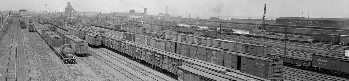

I’ve been planning a new layout since late in the summer of 2019. I came across the image above a few years ago and it has inspired research into the Baltimore & Ohio’s Allegheny Yard branch in Pittsburgh. In the lead image we see the Allegheny River and the School Street yard sitting on the north shore, circa 1923. Today, the Pittsburgh Pirates play baseball along this shore at PNC Park. The stadium dominates the scene and would be hiding the building with the Teaberry Gum sign.
All images in this blog post are from the Pittsburgh City Photographer collection on the Historic Pittsburgh site, unless noted otherwise.
This six-mile branch was originally the Pittsburgh & Western. The Buffalo, Rochester & Pittsburgh Railway used trackage rights to the School Street yard, which was their southern freight terminus. The B&O bought the P&W about 1905, mainly for the connection from Pittsburgh to New Castle, Pennsylvania, and into Ohio.
The branch started at the Willow Island yard, about three miles upriver from the School Street facilities. I can’t model all of the line but want to start on a few sections with operational possibilities.

One building that stands out is the poured concrete B&O Stores structure. It’s 350 long across the front and has three interior tracks with a 12-car capacity. A depot near the building acts as a yard office for the branch. It’s also interesting as it is on 16-foot legs to keep it above the river’s flood stage.
And yes, that is a Heinz pickle tank car in the lower left corner. The H.J. Heinz plant was served by this branch.

I bought the ICC valuation maps for the branch several years ago from the National Archives at College Park. These have offered more information and ideas for the layout. The above image is an edit of a much larger map but you can see many details, such as the three tracks inside the building and the elevated depot.

Another scene I’d like to model is adjacent to the B&O Stores building but has an older appearance. The above image dates from 1911 and shows a simple scene with a couple tracks, a warehouse, and a gantry crane. The larger buildings are part of the United Storage company complex.

Luckily, the city photographer snapped a photo from the other end of this scene on the same day. Possibly, the photographer was documenting an area that will undergo a public works project in the near future.
Look closely at the background of these images and you will see bridge approaches at each end of this scene. This warehouse spur does double duty as a team track. The gantry crane was a nice surprise.

Here’s the valuation map detail for the United Storage area. The part at the far left is also on the previous valuation map of the Stores building area. The bridge approach separates these two scenes while the Stores building lead comes off the main tracks in this map.

The B&O published Form 6 books documenting lots of details on the system. Offices, agents, stations, sidings, mileage, and customers were featured. The above image is an edit of the Allegheny Yard branch listing for these sections. The bold Allegheny is the depot name, which comes from the original municipality name for the area. The north side was originally incorporated as Allegheny City and annexed by the city of Pittsburgh in 1907.
The letters beside the depot name note various rail facilities nearby; derricks or cranes (D), coaling point (K), turntable (T), and water (W). The Stores building had tenants, noted in parenthesis, with a car unloading capacity of 13. The K30A, K31, and K32 notes are the track names.

Aerial imaging came along in the 1930s and there are many available through the Penn Pilot collection sponsored by the Pennsylvania Geologic Survey. The earliest Pittsburgh coverage dates to 1939. The above edit features the sections described earlier with call outs. The United Storage buildings are gone by this point and now a parking lot.
The bridges crossing the Allegheny River define the individual scenes. To the left is another section I want to model as it features the BR&P freight house and a large paper distributor; Alling & Cory. I will focus on the B&O stores and the Union Storage scenes first.
Modeling the branch
I will keep my original rules established when I built the Wheeling Freight Terminal layout.
- Keep it Simple
- Reuse what is on hand
- Build to be flexible for future projects
I plan to use the Wheeling Freight Terminal yard to represent the Willow Island yard connection. The rest of the layout will be built as sections for easy transport. This time around, I’m going to use 24-inch wide hollow core doors for a couple sections. I plan to install three-inch wide plywood at the ends to ease connections with other sections.

A friend gave me a couple of hollow core doors but I didn’t realize they were 30-inches wide until after I had prepped them for paint. I decided to use one as a planning tool so I could see what fits. A line of painters tape was placed at the 24-inch mark to define the proper width.
I’ve been building #6 track switches using Fast Tracks jigs and placed them with track and #5 track switch templates to see what can fit. Do you recognize the track layout here from the photos and valuation maps earlier in the post?

Here’s a look from the opposite direction. The B&O Stores tracks are on the left, close to the blue tape. There are two running tracks for the branch and another shorter runaround closer to the river, on the right. The operating aisle will be on the right.
The doors are 78-inches long and offer a stable base for a layout. There are no grades on this line. I don’t want the running tracks to be parallel to the front edge but follow at a slight angle. Joints across the door sections will be at slight angles as I had difficulty with track crossing section joints at sharp angles and curves on the Wheeling Freight Terminal.
I’ve been ready for another layout adventure for a while and look forward to moving this new project along. There are many other elements of this branch attracting my interest but these two sections are my primary focus to start.
Thank you for visiting the blog. You can share a comment in the section below. Follow the instructions so your comment can be posted. All comments are reviewed and approved before they appear. Please share the blog link with other model railroaders. To subscribe to this blog, add your email address to the function at the bottom of the right column on the main page.
That’s going to be very interesting to work I like the idea of using doors
That sounds like an awesome layout!! Lots of cool detailing and operations. Keep us posted on your project.
Eric,
Apparently you are modeling Allegheny in the mid to late 1920’s? Just a few FYIs. The roundhouse you see in the panorama is the 2nd incarnation of a roundhouse partially surrounding the turntable that replaced the original P&W structure. Much so the B&O Stores building occupies the basic same footprint of the original P&W train shed and freight house combination passenger baggage building. The large rectangular freight house being on the 7th Street side with the angular Passenger & Baggage Depot on the 9th street portion.
No matter what time period it is proper to use the terminology Willow Grove as in the P&W/B&O Yard where the P&W met the Pittsburg(h) Junction Railroad at Herr’s Island at James Callery’s stockpens. Herr’s Island was never referred to as Willow Island.
George K.
Thank you for your comments, George! My focus is November 1926 so many of the original P&W facilities have been updated or replaced. It’s interesting to view the interactive historic Pittsburgh map site. Changing the map era layers illustrates many of the physical and industrial changes over the decades. Modeling the School Street yard and locomotive facilities will have to wait for a better layout space. Focusing on these first couple of scenes should accelerate the project to an operational stage. I’ll be sharing more as it moves along. – Eric H.
Very intesting area to model and I am looking forward to following your progress.
I am curious to hear more about how you found what you wanted from the National Archives. Did you do all online research using their search tools, or did you visit College Park in person? Is there a particular starting point you recommend on their website?
Thanks for your comment, Dave. I had visited the College Park facility about 20 years ago while researching an earlier project. A friend was going there to research and I had the ICC valuation map section number. My friend was going to the map room anyway so he also requested the Allegheny Yard branch maps. They arrived with his research. He had the map room crew scan them at a high DPI as TIF files. They burned them to a disc and he mailed the disc to me. The key was the valuation section map number. That brings the focus to one segment of a large railroad system. – Eric H.
Ugh, as of today, the Penn Pilot collection you cite is no longer available through the link. The images are now available through something called PASDA which has a Pennsylvania Imagery Navigator. Link is here: https://maps.psiee.psu.edu/ImageryNavigator/
Thanks for your comment, Joe! I just updated that link. – Eric H.